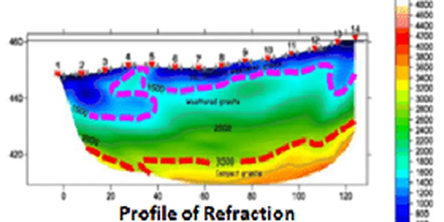
Here in Winnipeg, the subsurface tells a story that boreholes alone cannot fully capture. The city sits on thick glaciolacustrine clays deposited by glacial Lake Agassiz, and what lies beneath that—the limestone bedrock of the Red River Formation—drops unpredictably. We have worked on sites in St. James where bedrock shows up at 8 meters, then vanishes to 30 meters just two lots away. That is exactly where seismic tomography earns its place. A single seismic refraction line can map that bedrock trough before the excavator arrives, giving the structural engineer a continuous profile instead of interpolating between scattered boreholes. For deeper targets or urban noise environments, we often combine methods with MASW surveys to extract Vs profiles for site classification under NBCC 2020.
Seismic tomography converts travel-time curves into a continuous subsurface image, eliminating the blind spots between boreholes on Winnipeg's erratic bedrock surface.
Frequently asked questions
What depth can seismic tomography reach in Winnipeg clay?
With a 120-meter spread and sledgehammer source, we typically image 25 to 35 meters below grade. The depth limit depends on the clay thickness: the high-velocity limestone bedrock acts as a strong refractor, so the method works reliably until that interface is reached. For deeper targets beyond 40 meters, we recommend a downhole survey or a larger energy source.
How does seismic tomography compare to MASW for Site Class determination?
MASW directly measures shear-wave velocity (Vs), which is the parameter NBCC uses for Site Class (A through E). Refraction tomography gives us P-wave velocity (Vp). We often run both on the same spread: tomography maps the bedrock geometry, and MASW provides the Vs30 value. The two data sets together give a more complete geotechnical model than either alone.
What is the typical cost range for a seismic tomography survey in Winnipeg?
Seismic tomography surveys in Winnipeg generally range from CA$3,990 to CA$7,560 per line, depending on spread length, number of shots, site access conditions, and whether MASW is acquired simultaneously. Winter surveys can be more efficient on frozen ground, which sometimes reduces mobilization time.